Organic matter export rates along a North-South Pacific Ocean section: what three estimating methods tell us

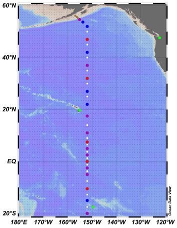
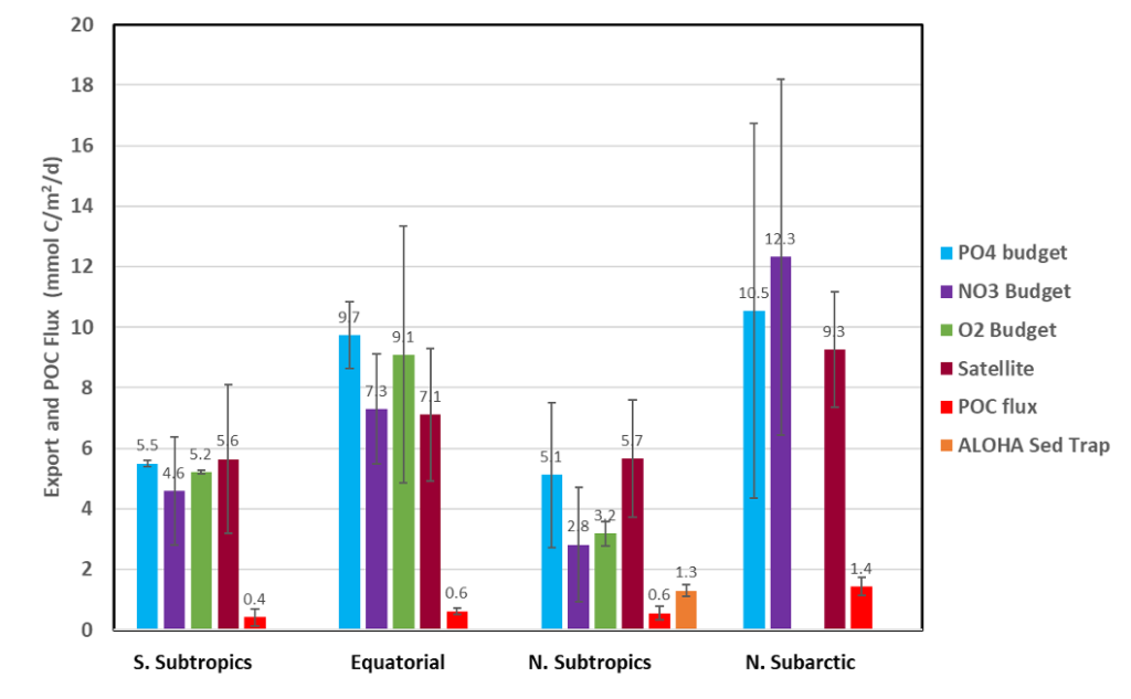
Quay and his colleagues (2025, see reference below) present estimates of the Organic Matter (OM) export rate based on surface budgets of nutrients (PO4 and NO3) and dissolved oxygen (O2) in the North Pacific Ocean during the GEOTRACES GP15 cruise between 50°N and 20°S.  Export rates estimates are highest in the subarctic and equatorial regions and lowest in the subtropical gyres with rates generally correlating with surface chlorophyll concentrations. The same regional trend is observed for export efficiency.  Independently, OM export rates were estimated based on satellite productivity models and showed similar regional variations as the budget-based export with the satellite rates being strongly dependent of the selected productivity algorithm.  When compared to estimates of particle sinking flux during GP15 the budget and satellite OM export rates were up to an order of magnitude higher.  These differences likely reflect the significant export of organic matter via dissolved OM and zooplankton migration in the oligotrophic subtropical gyres and the longer (months) integration times for the budget-based estimates than for particle sinking fluxes (weeks) in the subarctic region.

Reference:
Quay, P., & Stephens, M. (2025). Regional Patterns of Organic Matter Export Rates Along the GEOTRACES Pacific Meridional Transect GP15. Global Biogeochemical Cycles, 39. Access the paper: 10.1029/2024gb008277

Figure 1: The path of the US GEOTRACES research cruise (GP15) between Alaska and Tahiti during September- November 2018. The circles represent locations (stations) where the ship stopped to collect water samples for chemical analysis. The different colours indicate the number of samples collected at the station (white =12, blue = 24 and purple = 36).
Figure 2: Rates of organic matter export (transfer) to the subsurface ocean (>150m depth) for the subtropical (15-30°), equatorial (10°S-10°N) and subarctic (40-55°N) regions of the Pacific Ocean during a GEOTRACES cruise (GP15) in Fall 2018.  Export rates are estimated based on  surface layer PO4, NO3 and O2 budgets and, independently, from a model of plankton photosynthesis rates based on surface data measured by satellites.  In comparison, are estimates of the regional rates of organic particle sinking flux estimated from radioisotope measurements during GP15 and collected by sediment traps at the subtropical Stn. ALOHA (23°N 158°W) during Fall 2018.

Latest highlights

Unveiling the Complexity of Lead Distribution in the Pacific Ocean: Insights from the GEOTRACES GP15 Transect

This recent study by Jiang and colleagues investigate the distribution and sources of lead in the Pacific Ocean.

East-West contrasting fate and anthropogenic inputs for dissolved trace metals in the Subarctic Pacific Ocean

Chan and co-authors report the full-depth distribution of dissolved nickel, copper, zinc, and cadmium in the North Pacific Ocean.

Comprehensive quantification of the rare earth element cycle in the northwest Pacific Ocean

Cao and co-authors investigate dissolved rare earth elements and the factors controlling their distributions in the northwest Pacific Ocean.

Iron and zinc isotopes disentangle the anthropogenic, natural and wildfire sources of aerosols over the North and Equatorial Pacific Ocean

Bunnell and co-authors analysed aerosol iron and zinc isotopic compositions along the North Pacific GEOTRACES GP15 section (Alaska-Tahiti).

Rechercher