More insights on the natural fertilization processes of the KERGUELEN plateau
Rare earth elements (REE) patterns and neodymium (Nd) isotopic signatures of filtered and unfiltered waters collected as part of KEOPS GEOTRACES process study (mostly KEOPS 2, data compared to KEOPS 1 ones, acquired 6 years earlier) enabled Grenier and co-workers (2018, see reference below) to trace the transport of waters 200 km downstream from the coastal area, north of the Polar Front. Northward transport of the central Plateau shallow waters, enriched by both local vertical supplies and lateral advection of lithogenic inputs from Heard Island, was also revealed. Both confirm that lithogenic material released by intensive aerial and submarine weathering of Heard and Kerguelen islands are naturally fertilizing this area of the Southern Ocean. The authors also discuss that variations in REE concentrations and fractionations are also partly driven by authigenic processes, both inorganically and biologically mediated…
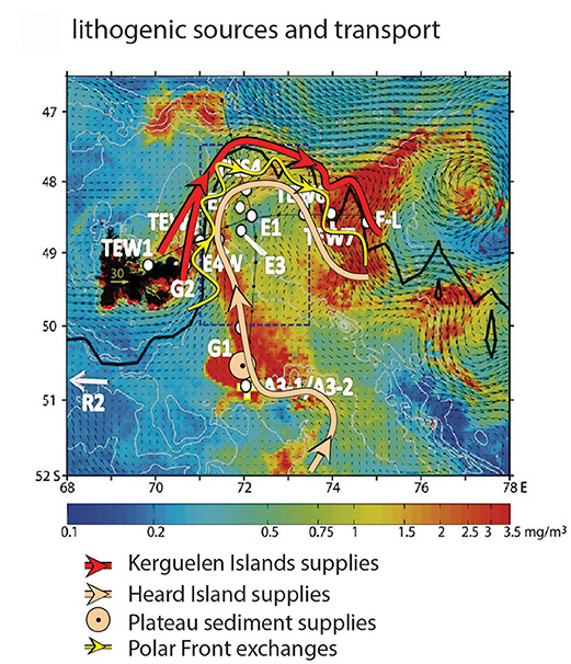
Figure: Oceanic transports of continental inputs from the Kerguelen Plateau, supplying the downstream annual spring bloom, one of the largest of the High-nutrient, low-chlorophyll (HNLC) Southern Ocean. Chlorophyll-a surface concentration of the KEOPS2 cruise period (colors), overlaid in by mean surface velocity field over the same period (arrows), shows the complexity of the bloom shape north and south of the Polar Front (PF; thick black line; Park et al., 2014). The schematized routes of continental supplies are suggested from the combination of the REE results (stations: white dots and names) with the regional oceanic circulation. These routes underline different geographical origins and transports of continental supplies: 1) inputs from Kerguelen Islands laterally transported north of the PF (red arrow); 2) inputs from Heard Islands laterally redistributed south of the PF (light pink arrow), fuelled by vertical inputs from the Central Plateau sediments (light pink arrowhead viewed from above); 3) exchanges of these sources across the PF (yellow arrow).
References:
Grenier, M., Garcia-Solsona, E., Lemaitre, N., Trull, T. W., Bouvier, V., Nonnotte, P., van Beek, P., Souhaut, M., Lacan, F., Jeandel, C. (2018). Differentiating Lithogenic Supplies, Water Mass Transport, and Biological Processes On and Off the Kerguelen Plateau Using Rare Earth Element Concentrations and Neodymium Isotopic Compositions. Frontiers in Marine Science, 5. DOI : http://doi.org/10.3389/fmars.2018.00426
Park, Y.-H., Durand, I., Kestenare, E., Rougier, G., Zhou, M., d’Ovidio, F., et al. (2014). Polar Front around the Kerguelen Islands: an up-to-date determination and associated circulation of surface/subsurface waters. J. Geophys. Res. 119, 6575–6592. doi: http://doi.org/10.1002/2014JC010061