A treasure of geochemical data to trace ocean circulation, ventilation, mixing, biogeochemical and hydrothermal processes
This treasure is made of approximately 60,000 valid tritium measurements, 63,000 valid helium isotope determinations, 57,000 dissolved helium concentrations, and 34,000 dissolved neon concentrations, including their metadata (geographic location, date and sample depth). It was compiled by Bill Jenkins and co-workers (2019, see reference below) who describe the nature of the data, discuss their quality, list the contributors and pioneers, and of course are giving free access to this huge dataset (https://doi.org/10.25921/c1sn-9631). They also provide some figures illustrating how powerful this new tool is as for example the figure below.
Authors invite anyone with knowledge of additional tritium, helium, or neon data that has not been included, to please contact wjenkins@whoi.edu with details for inclusion in future versions of the data set.
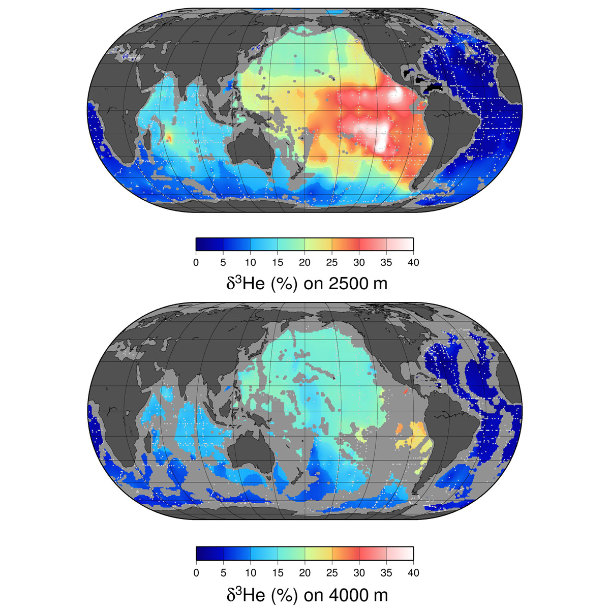
Figure: (top) A map of helium values at approximately 2500 m depth. (bottom) A map of helium values at approximately 4000 m depth. The values plotted are simply an average of all measurements within a 1’ square between 3750 and 4250 dbar. Depths shallower than 4000 m are masked in gray, and sampling locations are indicated by light gray dots. Click here to view the figure larger.
3He is an extremely rare isotope that is a sensitive tracer of hydrothermal processes. Since it is both stable and chemically inert, it is detectable over great distances in the ocean. The two maps shown above are of the distribution of δ3He, a tracer of hydrothermal activity, at two levels in the deep ocean. The shallower one roughly corresponds to the depth of the mid-ocean ridge system, where the bulk of this hydrothermal injection takes place. One can see the dominant role of the fast-spreading ridges in the eastern Pacific, which drive two massive, westward reaching plumes north and south of the equator. The deeper horizon shows the spreading of δ3He-impoverished bottom waters from the northern and southern polar regions into the deep ocean basins.
Reference:
Jenkins, W. J., Doney, S. C., Fendrock, M., Fine, R., Gamo, T., Jean-Baptiste, P., Key, R., Klein, B., Lupton, J. E., Newton, R., Rhein, M., Roether, W., Sano, Y., Schlitzer, R., Schlosser, P. Swift, J. (2019). A comprehensive global oceanic dataset of helium isotope and tritium measurements. Earth System Science Data, 11(2), 441–454. DOI: http://doi.org/10.5194/essd-11-441-2019