The GEOTRACES Intermediate Data Product 2025 (IDP2025) is the fourth release of publicly available data products, comprising hydrographic and marine biogeochemical measurements collected on 123 cruises. It represents a substantial expansion of the dataset released in 2021, which is also fully included in this edition.
The IDP2025 contains trace elements and isotopes (TEI) that serve as micronutrients, contaminants (e.g., Pb and Hg), radioactive and stable isotopes including those used in paleoceanography and a broad suite of hydrographic parameters used to trace water masses, as well as, it provides microbiological data. The dataset thus covers a wide range of biogeochemical parameters, as well as aerosol and precipitation data characterising atmospheric TEI sources and cryosphere TEI data from the Arctic.
The TEI data in the IDP2025 are quality controlled by careful assessment of intercalibration results and multi-laboratory data comparisons at crossover stations.
Compared to previous release in 2021, IDP2025 improves data coverage in all ocean basins. Overall, the new data product contains 18 new cruises, 732 new stations (4,097 stations in total) and 448,050 new data values (2,199,291 in total). As an example, the number of dissolved iron values has increased by 7,463 to 23,912 in the IDP2025.
By releasing the intermediate data products, GEOTRACES aims to intensify collaboration within the broader ocean research community but also seeking feedback from the community to help us improve future data products.
| >>> Please help us to improve the IDP by sending us (ipo@geotraces.org) your feedback <<< >>> The IDP2025 was released on 20 November 2025. To mark the launch, a webinar was held on two dates—20 and 25 November. You can view the full event recordings from either 20 November or 25 November. Or watch individual speaker videos included in the launch webinar programme here or in the GEOTRACES YouTube channel.>>> |
The Product
The IDP2025 version 2 consists of two parts:
(1) the digital data (hydrographic and biogeochemical data from 123 cruises, covering the global ocean) and
(2) the eGEOTRACES Electronic Atlas
(1) Access GEOTRACES digital data:
There are 4 ways to access GEOTRACES data to accommodate different users:
1. Bulk (full packages) download – 3 formats: ASCII, NetCDF and Ocean Data View (ODV) collections through the DOI: 10.5285/42c92148-8d03-8be6-e063-7086abc09f0c
>>Should you need any other data format please contact the GEOTRACES IPO at ipoNO SPAM -- FILTER@NO SPAM -- FILTERgeotraces.org
2. Online sub-setting and extraction (WebODV Extractor online*) – easy to select variables, region, cruises, etc. Please use the webODV Explore service at: https://geotraces.webodv.awi.de/
3. Online analysis, exploration and visualization (WebODV Explore online*) – very user friendly, no need to download software or data: https://explore.webodv.awi.de/ (Please navigate to “Ocean > tracer > geotraces > idp2025”).
>>The videos below show you how to work with IDP data using the webODV tool (right) and how to use IDP for teaching (left).
(2) The eGEOTRACES Electronic Atlas
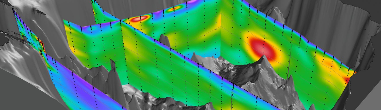
The eGEOTRACES Electronic Atlas (available at www.egeotraces.org is based on the digital data package and provides section plots and animated 3D scenes for many of the parameters, allowing quick overviews of the occurrence of geochemically relevant tracers. The 3D scenes provide geographical context crucial for correctly assessing extent and origin of tracer plumes as well as for inferring processes acting on the tracers and shaping their distribution. The numerous links to other tracers, sections and basins found on section plots and 3D animations allow quick switching between parameters and domains and facilitate comparative studies. In addition, eGEOTRACES can help in teaching and outreach activities and can also facilitate conveying societally relevant scientific results to interested laymen or decision makers.
A special effort has been made to link information about data originator, original publications and analytical methods with every data value. Proper linkage to and prominent display of originator information is used throughout the IDP and considered important to provide credit to data producers.
Usage: Users select parameters, cruise tracks and ocean basins using list-boxes and interactive maps. eGEOTRACES then presents parameter distributions along the selected sections, or animated 3D scenes showing parameter distributions along all available sections in the selected basin.
>> The video on the right includes a live demonstration of how to use the eGEOTRACES Atlas at minute 11:41.
GEOTRACES IDP Fair Use Agreement and citation
The GEOTRACES IDP2025 is open access, released under the Creative Commons By Attribution (CC-BY) Licence 4.0 as described in the Fair Use Agreement.
Please cite the IDP2025 as:
GEOTRACES Intermediate Data Product Group (2025). The GEOTRACES Intermediate Data Product 2025 (IDP2025). NERC EDS British Oceanographic Data Centre NOC. doi:10.5285/42c92148-8d03-8be6-e063-7086abc09f0c
IDP related helpful tools and videos
A page featuring helpful tools developed by IDP users, which their developers have made available for others, is available here.
Additionally, you can learn more through the IDP videos and tutorials on the GEOTRACES YouTube channel, including the ones available below.
Links for previous GEOTRACES IDP versions and historical TEI data
Note: Each new version of the IDP contains the data of the previous versions of the IDP.